Showing posts with label majors path. Show all posts

Wednesday, August 2, 2017

Day #10 on the Paumanok Path...

Rosa and I decided to squeak in a short hiking day today, as our schedules allowed for an hour or so.  We knew we had a nice 2 . 5 mile clip we could complete, so we decided to go for it.  I invited Dakota to join us, and happily, she accepted.

We began where we left off last weekend, at the intersection of Majors Path and Cove Neck Lane. It was about 12:30 when we began, so the heat was in full force by the time we stepped on the trail. This section was pretty uneventful, as we traveled around the southern border of the Southampton Landfill, and up and over some pretty steep terrain. We thought we were done with these kinds of hills once we finished the Manorville section, but I guess not!


We came across this fallen tree, which from afar looked like a giant spider, and some dirt bikers, who thankfully slowed as they passed us on the trail.

It was a great day, and it was really nice to have Dakota with us today. She taught us about the gender of pine cones, lichen on the trees, and even cleared some spider webs as we walked (that's what happens to the line leader).

We went a distance of 2 . 38 miles, all of which were in the woods, which was nice. Other than the heat sucking the life out of us, we had a great day.

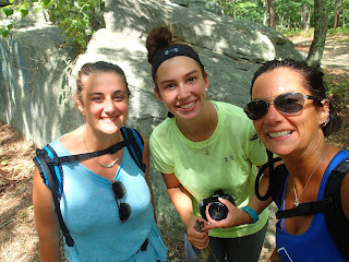
We came up to one of the largest glacial erratics we have seen, Dakota climbed to the top, took some pics, and of course, we had to take a selfie before we left! We saw the word "PROM?" in blue paint across the front side of the rock ~ although quite the romantic gesture, this beautiful rock is now blasted with blue paint for all to see. I was a bit disappointed about the paint, but it was still a beautiful spot to see right before we exited the woods.

The trail exits out onto Great Hill Road, just west of a large tower.  This will make it easy for us to find it's entrance on our next hiking day.

We are moving right along, with a little over 70 miles under our feet. Our goal is to complete the trail before Dakota returns to college on the 27th of this month. We are on track to accomplish this goal, so we are very excited.

You can check out our progress on the map below.


Until Next Time,

Rosa & The Thruhiker's Wife

Sunday, July 30, 2017

Day #9 on the Paumanok Path...

What a beautiful for hiking! We were up, and out on the trail today by 8:30 am.  Today's endpoint was uncertain at first, as there is nothing posted ANYWHERE about this section of the trail.  We drove around the area near the landfill in Southampton, and decided to leave my jeep parked on the side of a road called Majors Path, with a note on my window saying "Out hiking ~ will return to my car" so no one would think my jeep was abandoned. We began at last week's endpoint, the Preserve entrance on Millstone Brook Road. Most of today's hike was in brisk air,  mostly walking  in the woods, with beautiful views, great company and NO TICKS.


Although there is almost no information on this section of the trail, and it's development, I can happily say the blazes in this section are well marked, and the trail is very well maintained.  There are a few sections where we were on the road for a bit, but it was great as we walked passed other friendly people, exercising, riding bikes, mowing their lawns, and just outside enjoying the beautiful weather.  We both agreed it was one of our favorite sections of the trail so far.

The trail wound through the Wolf Swamp Sanctuary for the first mile, we crossed over Scotts Road, over another section of Millstone Brook Road, and came up on Big Fresh Pond. It was a beautiful, calm body of water set in the middle of what felt like nowhere.
Pond selfies!
Big Fresh Pond


After enjoying the view on the shore of Big Fresh Pond, we continued walking and entered into Emma Rose Elliston Memorial Park.  There is a beautiful monument in the park, dedicated to the residents of Southampton Town.

photo by Carole Warren


This park was beautiful, with many small foot bridges helping us cross over little streams throughout the park. Normally we know when we are coming up to any type of water, as the mosquitoes begin buzzing all around us, but not today! It was peaceful and beautiful throughout the mile we were in the park.

We exited the wooded area, crossed over North Sea Road, and proceeded to navigate in and out of the woods, and through some residential areas, hosting beautiful homes and friendly people.

As we approached the next crossing of a road, which happened to be North Sea Drive, we stopped a nice couple who were walking their baby in a stroller to ask if they knew how far away the landfill was.  We knew it was where I had left my jeep, so we were hoping it wasn't too far from where we were.  They said, yes, it was just around two corners right up the road! We were so happy and proud of where we estimated we should have left the jeep.  We proceeded through about a half mile of more woods, and the trail dumped us out onto Cove Neck Lane.  Wait, where have I seen that before? Oh yeah, I looked to my right, and there sat my jeep, note still attached, undisturbed. We had successfully found the car, completed 4.8 miles, and felt so great about our day.  I took a picture earlier in our day, while still in the Memorial Park that just about sums up our day:

photo by Carole Warren
You can see our progress from today on the map below. Cumulatively, we have completed a little over 70 miles of the 125 mile total that we want to finish. We are right on schedule, and looking forward to getting a few hiking days in this week, so stay tuned!


Until Next Time,

Rosa & The Thruhiker's Wife